Viridien completes reimaging of BM-S-2 multi-client survey in Brazil’s southern Santos Basin
Published by Elizabeth Corner,
Senior Editor
Oilfield Technology,
Viridien has successfully completed the BM-S-2 seismic reimaging project in the southern Santos Basin, delivering a modern, high-fidelity 3D dataset across 8468 km2 to support growing exploration activity in one of the most strategic, emerging offshore regions of Brazil.
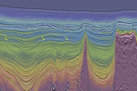
The project upgrades a large legacy survey with the latest advanced imaging technologies, including time-lag full waveform inversion (TL-FWI), to provide clearer definition of post-salt stratigraphy, improved visibility of potential direct hydrocarbon indicators (DHIs), and new insights into underexplored pre-salt plays. The reimaged BM-S-2 survey seamlessly integrates with Viridien’s broader Constellation Extension survey, creating unified regional coverage that supports both play-scale screening and detailed prospect assessment across South Santos.
Dechun Lin, Head of Earth Data, Viridien, said: “The BM-S-2 reimaging project represents a timely investment by Viridien in a rapidly evolving exploration corridor. By transforming a large vintage dataset with our state-of-the-art imaging technologies, we are providing the industry with the clarity needed to evaluate new opportunities with confidence and to de-risk early-stage exploration and licensing decisions.”
Image: Least-squares Kirchhoff PSDM (LS-KPSDM) full stack seismic image overlaid with the 12Hz TL-FWI velocity model. In this example, the high-resolution LS-KPSDM image and geologically-conformal FWI model together clearly show flat spots (indicated by arrows) – DHI-supported leads highlighting potential hydrocarbon reservoirs (image courtesy of Viridien Earth Data).
Read the article online at: https://www.oilfieldtechnology.com/exploration/22122025/viridien-completes-reimaging-of-bm-s-2-multi-client-survey-in-brazils-southern-santos-basin/
You might also like

BOEM analyses proposed offshore well stimulation work at platform Gilda offshore California
The Bureau of Ocean Energy Management has issued a Notice of Intent to prepare an Environmental Impact Statement for a proposed update to the Santa Clara Unit Development and Production Plan, which includes the use of hydraulic fracturing on 16 existing wells at Platform Gilda, located 8.8 miles offshore Ventura County, California.